|
Metairie (Images of America) |
|
|
|
Old Metairie |
||
|
|
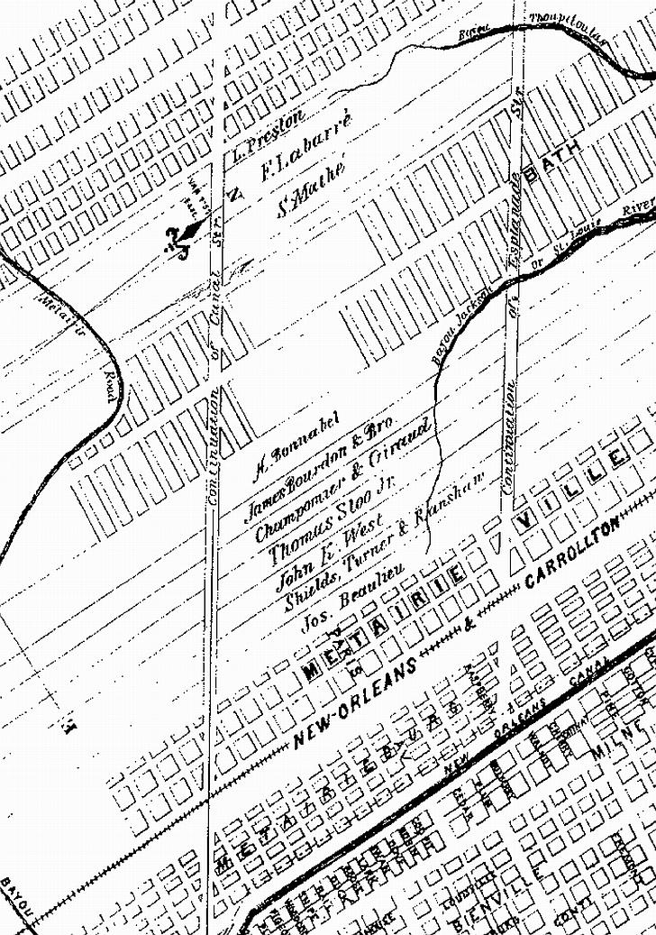 This detail from a map drawn in 1867 includes the names of landowners. They include L. Preston, F. Labarre’, S. Mathe’, H. Bonnabel, James Lourdon & Bro., Champomaer & Giraud, Thomas Sloo Jr., John, K. West, Shields, Turner, & Ransham, and Jos. Beaulieu. Large tracks of land were still held at this time. The names Bonnabel and Labarre are familiar today as street names. (Courtesy of the Louisiana Digital Library.) Metairie Road was the community’s first main street dating back to ancient days. In post-modern times it was similar
in many ways to every small town’s main street. Residents of Old Metairie, unlike those in many or the newer subdivisions,
had easy access to goods and services along Metairie Road during the era before shopping centers sprouted up along the newer
major highways In 1910 Metairie Road was still topped with dirt as was Shrewsbury Road. Early
20th century land owners included, from the 17th street canal to Shrewsbury Road (on the lakeside of
Metairie Road), Earnest Paul Riviere, Peter Betz, Henry DeLimon, John Betz, John Palmisano, Alfred Bonnabel, Charles Persigo,
Charles Rolling, John Bertucci, and Frank Fagot (whose store was located at what is now Bonnabel Boulevard at Metairie Road
which the location of the first telephone in Metairie). On the riverside, large tracks were owned by Andrew Fredericks, John
Vincent, Valentine Betz, Adolph Ricks, the Peters family (later named the Codham Tract), a group of Chinese families (?),
Dan Newsham, Charles Root, the Marshall family, the Babin family (at Labarre Road which included a blacksmith shop), and the
Shultz family (who were said to be an opera singing couple). Above Shrewsbury Road plantation property still ran from the
river to the lake. Metairie Club Gardens and Golf Club was carved
from cypress swampland in 1926. By 1937 residential developments included Athania Place, Beverly Knoll, Bonnabel Place, Brockenbraugh
Court, Crestmont Park, Elmeer Place, Farnham Place, Forest Hills, Livingston Place, Metairie Terrace, Oak Ridge Park, Ridgeway
Terrace, and Vincent Place. In 1938 a street lighting district was created and Metairie Road offered a shopping center, grocery
stores, bakeries, hardware stores, restaurants, neighborhood bars, and a movie theater. In 1946 Metairie Savings Bank and
Trust Company was established In 1954 Bayou Metairie alongside Metairie Cemetery was filled.
In 1955 the all-women Krewe of Helios was formed. The Krewe of Zeus was organized at Genarro’s Restaurant and
Bar. The 1960’s brought the Do Drive-In to Metairie Road on a piece of land that was a greyhound track during the 1920s.
. Metairie Road is laid out with odd numbered addresses on
the lakeside. In the following chapters street addresses may appear in parenthesis.
|
|
|
|
||