|
New Orleans Maps |
|
|
1728 Plan de la Nouvelle Orleans Capitale de la Louisiana
|
||||||||||||||||||||||||||||||||||||||||||||||||||||||||||||||||||||
|
|
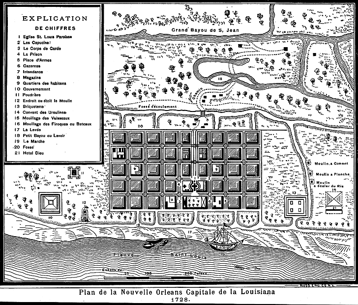 1728 map depicting Grand Bayou de S. Jean (Bayou St. John), the oaks,
and the “winding path [Chemin] made by the Indians...[which] ran through a thick forest, and connected the Indian village
with the French settlement of New Orleans” (LDL). Also
here are Eglise St. Louis Paroisse (Church St Louis Parish), Les Capucins (the Capuchin monks), le Cord de Carde, La Prison
( the Prison), Place d'Armes (the Arsonal), Cazernes, Intendance, Magazins, Quartiers des Habitans, Gouvernement Poudrier,
Endrouit ou e'toit le moulon, Briqueterie (Brickyard), Convent de Ursulines, Moullage de Vaisseaux, Moullage de Firoques ou
Batcaux, La Levee, Petit Bayou ou Lavoir, Le March (the market), Fosse', and Hotel Dieu (hospital). Note that the Mississippi River is called "Flauve Saint Louis".
|
|
||||||||||||||||||||||||||||||||||||||||||||||||||||||||||||||||||
|
|
||||||||||||||||||||||||||||||||||||||||||||||||||||||||||||||||||||